Introduction
In the dynamic world of aggregate sales, staying at the forefront of technology can be the key to unlocking unprecedented efficiency and profitability. Enter drone mapping for aggregate businesses—a revolutionary tool that has reshaped the landscape of the industry. In this blog post, we’ll explore the game-changing benefits that drone mapping brings to aggregate companies, offering precision, speed, and a competitive edge in the market.
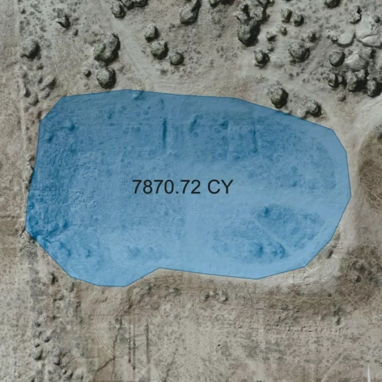
1. Precision in resource assessment
For aggregate companies, accurate resource assessment is the foundation of successful operations. Drone mapping provides a level of precision that traditional methods simply can’t match. Equipped with high-resolution cameras and advanced sensors, drones capture detailed imagery, allowing for precise measurements of stockpiles and quarry volumes. This accuracy is instrumental in optimizing resource extraction, reducing waste, and maximizing profits.
2. Efficient inventory management
Managing inventory is a critical aspect of the aggregate business. Drone mapping streamlines this process by providing on-demand data on stockpile quantities and conditions. This information enables companies to make data-driven decisions, ensuring that inventory levels are optimal and preventing costly shortages or overstock situations.
3. Rapid site surveys
Traditional surveying methods can be time-consuming and labor-intensive. Drones, on the other hand, cover large areas quickly and efficiently. This rapid survey capability is especially beneficial for aggregate companies, allowing them to assess new sites or expansions with speed and accuracy. Time saved in the surveying phase translates directly into reduced operational costs and faster project timelines.
4. Enhanced safety and compliance
Ensuring the safety of employees and compliance with regulatory standards are paramount concerns for aggregate companies. Drones contribute significantly to safety by minimizing the need for manual inspections in potentially hazardous areas. Additionally, the detailed data provided by drone mapping aids in compliance efforts by documenting site conditions and ensuring adherence to environmental regulations.
5. Precise reporting
Aggregate companies often require detailed reporting for internal analysis and regulatory compliance. Drone mapping facilitates customizable insights, allowing companies to generate accurate and detailed reports on stockpile volumes, site conditions, and other critical metrics. This capability not only streamlines internal processes but also enhances transparency and communication with regulatory authorities.
6. Competitive edge and innovation
In a competitive market, staying ahead of the curve is essential. Embracing drone mapping not only improves operational efficiency but also positions aggregate companies as industry innovators. Demonstrating a commitment to cutting-edge technology can be a valuable differentiator, attracting customers and partners who value efficiency, accuracy, and forward-thinking practices.
Conclusion
For aggregate companies looking to rise above the competition, drone mapping is a game-changer. From precision resource assessment to efficient inventory management and enhanced safety, the benefits are as concrete as the materials they extract. Embrace the power of aerial insights and position your aggregate business at the forefront of industry innovation. With drone mapping, the sky’s the limit for optimizing operations, maximizing profits, and cementing your place as a leader in the aggregates market.
Contact TopoMatters to learn how you might realize an immediate ROI with the power of drone mapping.