

LiDAR and photogrammetry-based deliverables for professional land surveyors
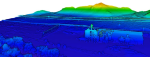
LiDAR Scan to Colorized Point Cloud
Fashionably called a “digital twin,” the point cloud offers a current perspective view of your survey limits and surroundings. A point cloud contains millions of pixels, each 3D geo-referenced and contains RGB color, intensity and laser return data. Point cloud models are further post-processed to deliver CAD and GIS friendly files that are ready to be incorporated into your project design workflow.
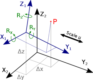
Seven Parameter Localization
Most projects require data in local ground-scaled coordinate systems. In this case, ground control point coordinate pairs are applied to transform the point cloud to the project’s local coordinate system prior to further processing. If your deliverables are in State Plane or UTM coordinates, this step is not required.
TopoPro® LiDAR Post-Processing
Benefit from a specialized workflow developed by TopoMatters to generate high-precision, survey-grade deliverables from drone-based LiDAR data. Unlike general-purpose drone mapping software, TopoPro® is tailored specifically for land surveyors, with accuracy, repeatability, workflow transparency and interactive QC at its core.
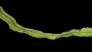
Digital Orthophoto Map
Straight-down, georeferenced imagery provides additional detail and context to your survey limits. The orthophoto is delivered in a GeoTIFF (.tif) file format, in a CAD layer as a compressed .ecw format, or can be viewed with Google Earth or a GIS tool that best suits your use case.
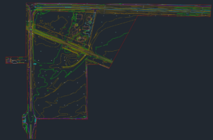
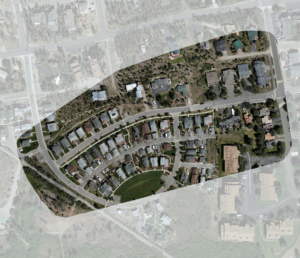
CAD Topographic Surface and Linework
Depending on your project, linework might be the only data that you need, without the data that you don’t.
Our CAD linework is professionally drafted from the LiDAR and orthophoto data collected from your project site, delivered as DWG 2D or 3D polylines, points and a Civil 3D surface.
Features that can be seen from the air can be captured in linework with incredible precision. TIN surface, contour lines, spot elevations, break lines, building drip lines, edge of road/curb/sidewalk, paint striping, tree locations and more.
Available Full Topographic + Boundary Survey
For our clients that are not licensed land surveyors, we can coordinate stamped topographic and boundary survey deliverables (and other land surveying tasks) offered through our partner network of professional land surveyors.