
When you’re successful, we’re successful!
Sharing how we’re wired helps us get off to a great start!

A growth mindset
Quality-focused
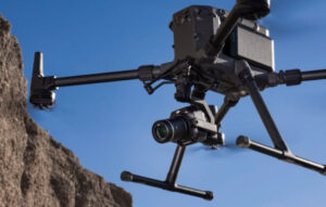
In order to deliver the best possible results, TopoMatters relies on industrial Unmanned Aircraft Systems (UAS) and data collection equipment, enhanced by our proprietary TopoPro® workflow to extract and test the most geometrically correct results. For example, we capture data with a full-frame sensor and a fixed-focus 35 or 24mm lenses designed specifically for photogrammetry flight missions and a 5-return LIDAR sensor for 3D scans, taking efficiency and accuracy to a whole new level. And for added safety, our aircraft have redundancy built into each of its critical systems.
Geo-referencing built-in
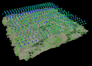
TopoMatters uses real-time kinematic (RTK), post-processed kinematic (PPK) and precise point positioning (PPP) GPS correction technologies and business processes to correct aerial data with centimeter-level precision.
Without location data correction, GPS coordinates of the horizontal and vertical drone position can have errors of several meters.
Take your data further

Prioritizing client success
With our rich experience leading B2B businesses at companies like Microsoft, Comcast, DISH Network and a global consulting firm, we’re confident we can help you make the best decisions to help you digitally transform your business and deliver the outcomes you expect.