

Survey-grade drone data shouldn't be guesswork.
TopoMatters brings accuracy and confidence to every aerial survey with repeatable, transparent workflows and interactive QC
Shatter the traditional tradeoffs between quality, speed, safety and investment with replicable UAS-based LiDAR service and photogrammetry workflows. Delivered with QC you can trust.

You establish control and check points, we’ll plan and fly the mission, process the collected data, perform quality assurance against known check shots, and work with you to hand off post-processing deliverables that fit into your workflow.
Expand your survey limits with TopoPro®
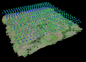
Precision Data Collection - LiDAR and Photogrammetry Service
Using industrial UAS equipment with RTK and PPK corrections, our photogrammetry and LiDAR service captures data with centimeter-level precision. This can lead to remarkable outcomes when it comes to processing the survey.
UAS data is collected in geographic latitude, longitude and ellipsoid heights, using a local RTK network to a reference base station positioned on a surveyed project point with LLH coordinates. Our data is post processed with PPK to further increase accuracy, and subsequently transformed to project ground coordinates using a 7-parameter (Helmert) transformation.
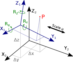
Seven Parameter Localization
Most survey projects require data projected in a local project coordinate system. Rather than ‘rubber sheeting’ collected data to control points, TopoMatters uses project point coordinate pairs to directly transform the point cloud to the project’s local coordinate system. We request five pairs of coordinates in both geodetic (lat/lon/ellipsoid height) and your local coordinate system (NEh / YXZ) to compute the transformation and residuals before data collection is performed.
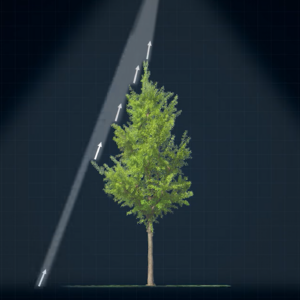
5 Return LiDAR = 5 Chances to Reflect Bare Earth
Whether collecting data amongst ponderosa pines, aspen groves or a sea of sage, 5 return LiDAR is a valuable technology that can enhance the quality and utility the LiDAR data. By recording multiple returns from a single laser pulse, 5 return LiDAR can provide more information, accuracy, and versatility for various applications and analyses. Learn more about our LiDAR system specs here.
TopoPro® Post Processing and Quality Reporting
Proprietary TopoPro LiDAR post-processing workflows assist professional land surveyors in transforming UAV LiDAR point clouds into precise terrain models and CAD surfaces, all while reducing point cloud bloat. TopoPro offers a transparent and repeatable workflow that emphasizes quality control and data integrity.
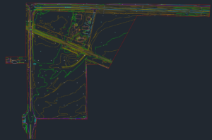
Planimetric and 3D linework
Once accuracy is verified, drone-based DWG deliverables can quickly establish a base project for your survey with the typical features you’d expect, including 2D or 3D polylines, spot elevation points, break lines, contours, a TIN or Civil 3D surface and more.
Bring your own ground shots
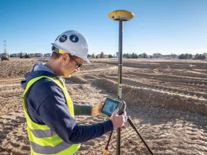
Good drone data will always be complemented by at least some ground work by the Professional Land Surveyor, including control, check shots, filler data for areas that can’t be captured from the air and of course monuments, boundaries and underground utilities.
A proud sustaining member of PLSC
As a sustaining member of the Professional Land Surveyors of Colorado, Inc. (PLSC), TopoMatters is proud to support the advancement of the land surveying profession and promote high standards within the industry. If you’re considering an aerial survey partner or just want to get to know us, TopoMatters’ focus on the surveying community demonstrates our dedication to industry excellence and trusted service.
TopoMatters specializes in capturing aerial drone data for professional land surveyors.

Request a free guide to learn more about our PLS engagement model and curated deliverables.
Get in Touch
Join our PLS Network.
- Bid more jobs, accelerate deliverables and increase revenue with TopoMatters LIDAR in your quiver
- Joint customized workflow design
- Co-sell joint business to leads generated by TopoMatters