

Precision Imagery to understand existing conditions, progression and the big picture view
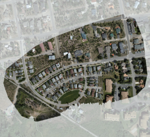
The “orthophoto” is a composed image similar to the straight down view you would experience in Google Earth, but with much more detail. It is created by collecting and processing many overlapping images which results in a view that is corrected for lens distortion, camera tilt, perspective and topographic relief. With this perfectly straight-down view, the orthophoto becomes a digital tool for estimating measurements and distance with confidence while also capturing incredible detail of your project site conditions. An orthophoto is delivered in GeoTIFF and JPEG2000 file formats or can be viewed with Google Earth or a GIS tool that best suits your use case.
Track Progression
Move the sliders below to view changes over time
[bafg id="1633"]