

Contours are those curved lines that trace out areas of equal elevation on a map. They’re like the topographic fingerprints of the land, revealing its ups and downs in a way that’s both intuitive and informative. But there’s more to contours than meets the eye. Did you know there are actually two main types of contours: cartographic and engineering topo (LiDAR maps)?
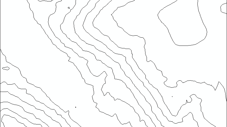
Cartographic contours are the ones you’re probably most familiar with. They’re the smooth, graceful lines that adorn traditional paper maps. Their purpose is to communicate the general shape of the land to a broad audience, often for hiking, sightseeing, or general understanding of an area. Think of them as the storytellers of the map, using their curves and bends to paint a vivid picture of the landscape. At TopoMatters we often produce cartographic contours from a grid of points (10 ft x 10 ft, or 25 ft x 25 ft, for example) derived from photogrammetry.
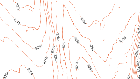
Engineering contours, often called LiDAR maps or LiDAR topo, are all about precision. They’re the workhorses of the map world, used for planning, construction, and other technical applications. These guys are rough and tough, following every bump and wiggle of the land with uncompromising accuracy. They’re not concerned with aesthetics; their job is to provide a detailed, no-nonsense picture of the terrain for engineers, surveyors, and anyone who needs to know exactly where the land goes. In this case, at TopoMatters we capture the ‘bare earth’ points needed to produce engineering contours with an enterprise grade LiDAR sensor.
So, what’s the difference between these two contour types?
Here’s a quick breakdown:
| Feature | Cartographic Contours | Engineering Contours |
|---|---|---|
| Purpose | General overview, storytelling | Detailed measurements, technical applications |
| Appearance | Smooth, generalized | Jagged, precise |
| Contour interval | Consistent, often wider | Variable, often narrower |
| Applications | General understanding of land features, GIS systems, community planning | Construction plans, engineering designs, land development |
Choosing the right contour map for the job
The type of contour you choose depends on your needs. If you’re telling a story or presenting a development plan, cartographic contours will help you communicate a good sense of the hills and valleys in your area of interest. But if you’re building a house, you’ll need the pinpoint accuracy of engineering contours from LiDAR maps or LiDAR scans to avoid any nasty surprises.
Ultimately, both cartographic and engineering contours play a vital role in our understanding of the land. They’re the silent heroes of the map, shaping our perception of the world around us, one squiggly line at a time.
Next time you look at a map, take a moment to appreciate the subtle art of contours. They may seem like simple lines, but they’re a powerful tool for understanding and shaping our world.
I hope this blog post has helped you see the difference between cartographic and engineering contours. If you have any questions, please contact us!
P.S. There’s also a hybrid type of contour called a “balanced” contour. These guys fall somewhere between cartographic and engineering contours, offering a balance of smoothness and accuracy. They’re often used for larger-scale maps or when a more moderate level of detail is needed.
Thanks for reading!