
Purpose-built post processing for US land surveyors.
Calibrate with confidence
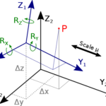
TopoPro’s 7-parameter transformation converts geo-referenced point clouds into ground-scaled project coordinates—preserving accuracy and ensuring seamless project integration.

Scalable tile processing
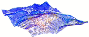
Point clouds can be unwieldy due to their size. TopoPro efficiently processes LAS tiles while indexing adjacent tile data to ensure seamless conformity across boundaries.

Multi-stage ground and built feature classification
If not already classified, TopoPro identifies ground points using multiple stages of deterministic, repeatable algorithms. Off-ground points are processed by local AI with best-effort classification of built features.

Smart thinning
Reduce point cloud bloat with TopoPro’s advanced smart thinning algorithm. The most geometrically reliable ground points are preserved to achieve the target point cloud density while removing redundant data.

Vertical bias adjustment
Aerial LiDAR scans often exhibit systematic vertical bias. TopoPro identifies and adjusts the Z-bias using project control, ensuring both ground and off-ground points align perfectly with the survey’s vertical control.

Clip to survey limits
Presentation matters. TopoPro clips the processed point cloud to your survey limits (plus a buffer), ensuring polished and professional results—all in your project’s ground or grid coordinate system.

Point cloud quality reporting
Using ASPRS-based methodologies, TopoPro validates data conformance against check shots. Detailed reports include vertical RMSE, deltaZ for individual shots, and alerts to quickly flag outliers for review.

Grade break and flow line computing
Identifying grade breaks and flow lines across a large survey area can be challenging. TopoPro simplifies this by using advanced algorithms to extract these vertices from the point cloud with direct integration into surface models.

3D breakline enforcement
Feature breaklines and CG points can be extracted from the post-processed point cloud and enforced in TIN surfaces, preserving sharp edges and the integrity of ground features.

Topo/TIN and terrain fit reporting
Enjoy high-quality surfaces, including points, contours, and a LandXML TIN. CAD models are tested against thousands of LAS points to ensure an accurate, simplified model.

Processing Transparency with Interactive Quality Report
Say goodbye to black-box processing. TopoPro’s interactive HTML report provides a step-by-step breakdown of LAS treatments and derivative extractions, complete with applied parameters, QC and 3D visualizations.