Photogrammetry or LiDAR? Upon searching for a drone survey company, many people quickly become overwhelmed with choosing best drone survey method for their particular project. In this blog post, we hope to help you quickly educate you to determine what’s best for your specific project.
Unmanned Aircraft Systems, ie drones, can carry different types of sensors to capture data from above, such as cameras and lasers. The two most common methods of drone surveying are photogrammetry and LiDAR. But what are the differences between them, and how do you choose the best one for your project?
Photogrammetry, or the science of making measurements from photographs, relies on images captured by cameras, which can be mounted on drones or other platforms. Photogrammetry uses the principles of geometry and perspective to reconstruct the 3D position and shape of the objects in the images, based on their relative size, shape, and location. Photogrammetry also uses the color and texture of the objects to create realistic and detailed models.
LiDAR, or light detection and ranging, is a remote sensing technology that uses laser pulses to measure the distance and shape of objects. LiDAR sensors work by emitting a series of laser beams in a fixed pattern, such as a rotating fan or a spinning cone. The laser beams reflect off the objects in the environment and return to the LiDAR sensor, where they are detected by a photodetector. The time it takes for the laser beams to travel back and forth is used to calculate the distance of each object. The angle and intensity of the laser beams are also recorded to determine the shape and reflectivity of the objects.
Both photogrammetry and LiDAR can provide surveyors with accurate, high-resolution, and comprehensive data about the terrain and its features, in a fast and efficient way. However, they also have some advantages and disadvantages that need to be considered, depending on the type of surface to be surveyed.
The most popular drone survey company option: Photogrammetry – often best for hard surfaces
Hard surfaces are those that have a smooth and uniform texture, such as concrete, asphalt, metal, or rock. Hard surfaces are ideal for photogrammetry, as they can reflect the light evenly and provide clear and sharp images. Photogrammetry can capture the geometry and dimensions of hard surfaces, as well as their color and texture, which can be useful for visualizing and analyzing the data.
The accuracy of photogrammetry depends on several factors, such as the resolution of the camera, the quality of the images, the number and distribution of the images, the camera calibration, and the software and algorithms used to process and analyze the data.
One of the most important factors is the ground sampling distance (GSD), which is the distance between two pixels as measured on the ground, from the center of each pixel. The GSD determines the level of detail and precision that can be achieved by photogrammetry. The lower the GSD, the higher the accuracy.
According to some studies, the relative accuracy of photogrammetry can be roughly estimated to be between one and three times the GSD. For example, if the GSD is 1 cm, the relative accuracy can be between 1 and 3 cm. This means that the features in the photogrammetric model can match each other within this range of error (Here’s a deeper dive on GSD for those inclined!).
However, this does not mean that the photogrammetric model matches the real-world coordinates of the features. For that, absolute accuracy is needed, which requires the use of ground control points (GCPs), which are known locations on the ground that are marked and measured with high precision. The GCPs are used to geo-reference and align the photogrammetric model with the real-world coordinate system.
Some examples of applications that can benefit from photogrammetry for hard surfaces are:
- Road and pavement inspection: Photogrammetry can detect cracks, potholes, and other defects on the road surface, and measure their size and depth. Photogrammetry can also provide information about the road markings, signs, and traffic conditions.
- Building and infrastructure inspection: Photogrammetry can capture the shape and structure of buildings and infrastructure, such as bridges, dams, pipelines, and power lines. Photogrammetry can also detect any damages, deformations, or displacements that may affect the safety and performance of the structures.
- Mining, quarrying and aggregates: Photogrammetry can measure the volume and shape of stockpiles, pits, and dumps, and provide information about the material composition, density, and quality. Photogrammetry can also monitor the progress and impact of the mining and quarrying activities on the environment.
The other critical drone survey company option: LiDAR – Best for vegetated surfaces
Vegetated surfaces are those that have a rough and heterogeneous texture, such as grass, bushes, trees, or crops. Vegetated surfaces are challenging for photogrammetry, as they can reflect the light unevenly and provide blurry and noisy images. Photogrammetry can capture the shape and height of the vegetation canopy, but it may not be able to penetrate the vegetation and reach the ground, which is important for creating a digital terrain model (DTM).
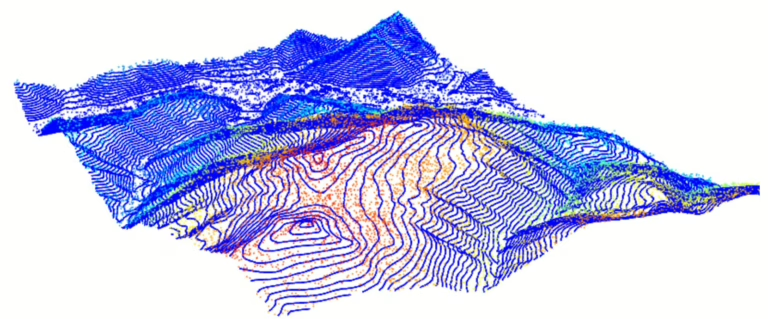
LiDAR, on the other hand, can overcome this limitation, as it can emit multiple laser pulses that can pass through small gaps in the vegetation and reach the ground. LiDAR can provide surveyors with both a digital surface model (DSM), which includes the vegetation and other features, and a DTM, which represents the bare earth.
LiDAR can also provide information about the vertical structure and density of the vegetation, which can be useful for estimating biomass, carbon storage, and biodiversity.
The accuracy of LiDAR depends on several factors, such as the power and wavelength of the laser, the scan angle and pattern of the laser beams, the number and distribution of the laser points (see our post about 5 Return LiDAR), the positioning and orientation of the LiDAR sensor, and the software and algorithms used to process and analyze the data.
However, one of the most important factors is the point density, which is the number of laser points per unit area on the ground. The point density determines the level of detail and precision that can be achieved by LiDAR. The higher the point density, the higher the accuracy.
With today’s mid-range LiDAR sensors, the system accuracy of LiDAR can be reach under 5 cm for both the horizontal coordinates (x and y), and vertical coordinate (z). This means that the LiDAR points can match the real-world coordinates of the features within this range of error. However, this does not mean that the LiDAR points can represent the exact shape and size of the features. For that, relative accuracy is needed, which requires the use of check points, which are locations on the ground that are independently measured and compared with the LiDAR points. The total accuracy of the survey is dependent upon the accuracy of the UAS system as well as the accuracy of the ground control points.
Some examples of applications that can benefit from LiDAR for vegetated surfaces are:
- Forest and wildlife management: LiDAR can measure the height and diameter of trees, and estimate the volume and biomass of the forest. LiDAR can also provide information about the species composition, diversity, and health of the forest, and identify potential habitats and corridors for wildlife.
- Agriculture and crop monitoring: LiDAR can measure the height and density of crops, and estimate the yield and quality of the harvest. LiDAR can also provide information about the soil moisture, erosion, and fertility, and detect pests, diseases, and weeds that may affect the crops.
- Flood and landslide risk assessment: LiDAR can create accurate and detailed DTMs that can help surveyors understand the topography, hydrology, and geology of the area, and evaluate factors such as terrain stability, flooding potential, and erosion risk.
Conclusion
Photogrammetry and LiDAR are both valuable and effective methods for drone mapping, but which produces the best drone survey? Each have different strengths and weaknesses that need to be weighed against the type of surface to be surveyed. Photogrammetry is more suitable for hard surfaces, as it can provide high-resolution and high-accuracy data, as well as color and texture information. LiDAR is more suitable for vegetated surfaces, as it can provide high-density and high-accuracy data, as well as vertical structure and density information.
These however are not absolute rules, and there may be cases where photogrammetry and LiDAR can complement each other, or where a hybrid solution can be used.
Reach out to us if you’d like to discuss the specifics of your project and get help choosing the most appropriate solution!