Surveying is the process of measuring and mapping the physical features of the Earth, such as landforms, buildings, vegetation, and infrastructure. Surveying is essential for many applications, such as planning, design, construction, management, and monitoring of various projects.
However, traditional terrestrial-based surveying methods can be time-consuming, labor-intensive, and sometimes unsafe. Moreover, traditional surveying methods may not be able to capture the full complexity and detail of the environment, especially in challenging or inaccessible areas. This is where LiDAR, or light detection and ranging, comes in.
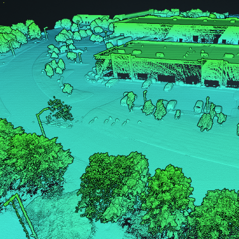
LiDAR is a remote sensing technology that uses laser pulses to measure the distance and shape of objects. LiDAR can provide surveyors with accurate, high-resolution, and comprehensive data about the terrain and its features, in a fast and efficient way.
Why LiDAR
LiDAR technology can also offer some unique advantages over other surveying methods, such as:
- LiDAR can capture the dynamic changes of the scene, such as moving objects or varying lighting conditions, by updating the data at each scan.
- LiDAR can provide data in 3D, which can reveal the spatial relationships and patterns of the features more clearly than 2D data.
- LiDAR can penetrate vegetation and clouds, which can be obscured from the view of other surveying methods.
LiDAR can be used for various types of surveying projects, such as:
- Topographic surveying: LiDAR can create detailed 3D models of the land surface, including the elevation, slope, aspect, and contour. This can help surveyors understand the topography, hydrology, geology, and ecology of the area, and evaluate factors such as terrain stability, flooding risk, and erosion potential.
- Bathymetric surveying: LiDAR can measure the depth and shape of water bodies, such as rivers, lakes, and oceans, by using a water-penetrating green light laser. This can help surveyors map the underwater features, such as reefs, sandbars, and shipwrecks, and assess the water quality, sedimentation, and habitat.
- Engineering surveying: LiDAR can capture the geometry and dimensions of structures, such as buildings, bridges, roads, and pipelines, by using a near-infrared laser. This can help surveyors design, construct, inspect, and maintain the structures, and detect any defects, damages, or deformations.
- Cultural heritage surveying: LiDAR can document the historical and archaeological sites, such as monuments, temples, tombs, and ruins, by using a high-resolution laser. This can help surveyors preserve, restore, and interpret the cultural heritage, and protect it from natural or human threats.
The Downside of LiDAR
However, LiDAR is not a perfect technology, and it also has some limitations and challenges, such as:
- LiDAR can be affected by motion blur, blind spots, and interference. Motion blur occurs when the objects move faster than the scanning speed of the LiDAR, resulting in distorted or incomplete data. Blind spots occur when the objects are too close or too far from the LiDAR, or when they are occluded by other objects, resulting in missing or inaccurate data. Interference occurs when the laser beams from multiple LiDAR systems overlap, causing noise or false readings.
- LiDAR can be expensive and complex to operate.
- LiDAR systems require high power and bandwidth, which can limit the range and resolution of the data.
- LiDAR systems also require specialized equipment, software, and personnel, which can increase the cost and difficulty of the project.
- LiDAR can generate massive amounts of data, which can be challenging to process, store, and analyze. LiDAR data can consist of millions or billions of points, which can create a huge demand for computing resources and storage space.
- LiDAR data also require sophisticated algorithms and techniques to filter, classify, and visualize the data, which can require advanced skills and knowledge.
LiDAR is a powerful and versatile technology that can enhance surveying projects in many ways. However, it also has some drawbacks and difficulties that need to be considered. LiDAR is not a one-size-fits-all solution, but rather a tool that needs to be adapted and integrated with other methods and data sources, depending on the needs and goals of each project. LiDAR is not only a technology, but also a science and an art.
If you’d like to learn more about why LiDAR may or may not be the best fit for your project, please feel free to reach out to us!