TopoMatters | Aerial LiDAR and Data for Surveyors
LiDAR, Photogrammetry and CAD Deliverables
Fast and efficient topo jobs.
More money in your pocket.
Born in the Colorado Rockies,
Mapping the Mountain West
Get your project off the ground quickly and efficiently.
Enjoy fast data collection, accelerated deliverables and happy clients with TopoMatters photogrammetry and LiDAR survey data
Land Surveyors
Save time and money with LiDAR and photogrammetry drone services, repeatable processing workflows and CAD linework that you can count on.
Planners + Designers
Enrich your planning and design process with current, high-fidelity perspectives available from aerial topographic base map data or 3D models, integrated into your workflow.
Architects + Engineers
Collect better data and make informed decisions with drone remote sensing that captures geospatial feature details and accelerates your deliverables.

Mountain West UAS
TopoMatters is a proud corporate sponsor of Mountain West UAS, a non-profit community where unmanned aircraft system users and stakeholders come together to learn, advocate and exchange information and ideas. Contact us if you’d like to learn more about how to get involved.
Drone Mapping Client Spotlights
5 Reasons to Consider TopoMatters
- Local Colorado mountain-based firm.
- Laser-focused specialization in drone mapping data and insights.
- Repeatable, fit-for-purpose processing pipelines.
- Experience with LiDAR data since 2017, UAS since 2021.
- Professional background blends technical excellence, business insights and high-performing alliances.
How to Get Started
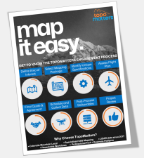
Enjoy smooth sailing with a simple and repeatable engagement process.
- Define the mapping area of interest
- Select a TopoMatters mapping package
- Identify any unique specifications
- Assess the mission flight plan
- Final quote and agreement
- Schedule flight mission and collect data
- Data post-processing and deliverables
- Project data review and CAD or GIS finishing
Request a free infographic guide to get you started on a TopoMatters mapping journey.
Have questions? Ready to go? Let’s Connect!
Learn how TopoMatters helps you challenge the tradeoffs between quality, speed and cost across the AEC journey.
- Planning + Design
- Land Surveying
- Architecture + Engineering
- Construction